KOREASAT 5A
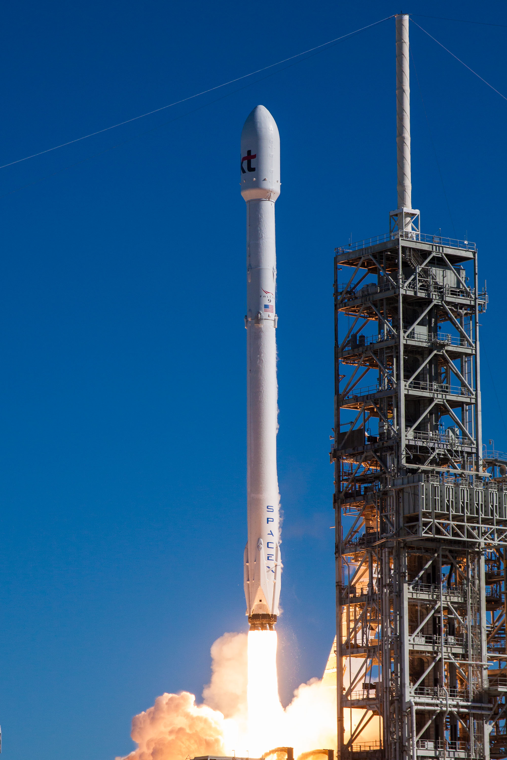
About KOREASAT 5A
KOREASAT 5A is a geostationary communications satellite operated by KT SAT, a South Korean satellite services company and subsidiary of the major telecommunications conglomerate KT Corporation. Assigned NORAD catalog number 42984 and the international designator 2017-067A, the spacecraft was launched in late October 2017 and remains operational in geostationary orbit. It was manufactured by the European aerospace firm Thales Alenia Space and serves as a key platform for broadcasting, broadband, and communications services across the Asia-Pacific region and the Middle East.
Mission and Purpose
KOREASAT 5A was developed to extend and reinforce South Korea's national satellite communications infrastructure. KT SAT, which manages the country's Koreasat fleet, relies on geostationary assets such as this one to deliver television broadcasting, broadband internet access, maritime communications, and government connectivity services to customers across a broad geographic footprint that includes the Korean Peninsula, Southeast Asia, and extending toward the Middle East.
The satellite functions as a commercial communications relay, receiving signals from ground stations and retransmitting them to receivers within its coverage zone. Geostationary spacecraft of this type are fundamental to the modern telecommunications landscape: because they orbit at an altitude where their orbital period precisely matches Earth's rotation, they appear essentially stationary over a fixed point on the equator, enabling continuous, uninterrupted communication links without the need to track a moving satellite. This characteristic makes them especially well suited for broadcast distribution, where a single transmission point must reliably reach millions of receivers simultaneously.
Specific details regarding the precise payload configuration of KOREASAT 5A — including the exact number and type of transponders, their frequency bands, and target coverage zones — are not recorded in the public satellite catalog entry associated with this object. However, in the broader context of KT SAT's operational history, the Koreasat series has traditionally carried Ku-band and Ka-band transponders to serve both consumer and enterprise markets. KOREASAT 5A was introduced in part to replace aging capacity and to expand service availability, continuing a lineage of South Korean commercial satellites that stretches back to the 1990s.
Orbit and Tracking
KOREASAT 5A occupies a near-perfect geostationary orbit, as reflected in the tracking data associated with NORAD ID 42984. Its apogee stands at approximately 35,797 km above Earth's surface, while its perigee is recorded at roughly 35,793 km — a difference of only about 4 km, indicating an extremely circular orbit with negligible eccentricity. The orbital inclination is recorded at 0.0°, meaning the satellite travels almost precisely along the equatorial plane. Its orbital period is approximately 1,436.2 minutes, which corresponds closely to one sidereal day, the hallmark characteristic of a geostationary orbit.
These orbital parameters place KOREASAT 5A in the geostationary belt, the ring of orbital slots roughly 35,786 km above the equator that is home to hundreds of commercial, government, and military communications satellites. Slots in this belt are a finite and internationally regulated resource, coordinated through the International Telecommunication Union, and are assigned to national administrations that license their use. The precise longitude of KOREASAT 5A's operational slot is not specified in the tracking record, but the satellite's orbital elements confirm it maintains the essentially fixed equatorial position characteristic of all operational geostationary satellites.
For tracking purposes, the object is cataloged as a payload — meaning it is the primary functional spacecraft, as distinct from the rocket body and debris fragments that can accompany any launch event. Because geostationary satellites appear nearly stationary relative to Earth's surface, they do not produce the brief overhead passes familiar to observers who track low-Earth-orbit spacecraft. Instead, from any location where the satellite is above the local horizon, it appears as a fixed point among the stars, indistinguishable by naked eye from a faint star. Specialized geostationary tracking is performed primarily by ground stations and by professional or advanced amateur astronomers using telescopes rather than casual sky-watching.
Design and Operator
KOREASAT 5A was manufactured by Thales Alenia Space, a joint venture between the French defense and aerospace company Thales and the Italian industrial group Leonardo. Thales Alenia Space is one of the world's foremost satellite manufacturers, with a long track record of producing commercial geostationary communications spacecraft for operators worldwide. The company brings considerable heritage in high-power telecommunications platforms to the Koreasat program.
The spacecraft has a launch mass of 3,500 kg, a figure typical of mid-to-large commercial geostationary communications satellites. Satellites of this mass class generally carry substantial transponder arrays and onboard fuel reserves necessary for maintaining their assigned geostationary position over a service life measured in decades through periodic stationkeeping maneuvers.
The satellite was lofted into orbit on October 29, 2017 (in coordinated universal terms, this corresponds to October 30, 2017, depending on time zone), aboard a SpaceX Falcon 9 Block 4 rocket. The Falcon 9 was, at that time, an established medium-to-heavy-lift launch vehicle that had become a dominant commercial launch platform globally. The Block 4 variant represented an incremental improvement in SpaceX's iterative development approach, offering enhanced performance relative to earlier versions of the rocket. The choice of the Falcon 9 for this mission reflected a broader trend of South Korean and Asian satellite operators selecting competitive Western commercial launch providers to deliver spacecraft to geostationary transfer orbit.
KT SAT, the satellite's operator, functions as the satellite services division of KT Corporation, one of South Korea's largest telecommunications companies. KT SAT manages the country's commercial satellite fleet and provides capacity to broadcasters, internet service providers, maritime operators, and institutional customers. The Koreasat brand under which these satellites operate has represented South Korea's commercial satellite presence since the 1990s, and KOREASAT 5A represents a continuation of that national investment in space-based communications capability.
Current Status and Significance
As of the most recent catalog data, KOREASAT 5A remains in orbit and has not undergone any recorded decay or reentry event. Geostationary satellites of this class are typically designed for operational service lives of fifteen years or more, sustained by onboard propellant that allows operators to perform the regular stationkeeping burns needed to maintain orbital position against the gravitational perturbations caused by the Moon, Sun, and Earth's equatorial bulge. Once propellant is exhausted, the spacecraft is generally maneuvered into a slightly higher "graveyard" orbit above the geostationary belt, where it will remain indefinitely without interfering with active operational slots.
KOREASAT 5A's significance lies in what it represents for South Korea's satellite communications sector. The country has built a sustained national capability in satellite operations over several decades, and each successive Koreasat mission has expanded the technical and commercial scope of that capability. Geostationary satellites like KOREASAT 5A underpin services that millions of users depend upon daily, from direct-to-home television broadcasting to enterprise-grade connectivity in regions where terrestrial infrastructure is limited or unavailable.
The satellite also reflects South Korea's continued willingness to partner with international industry leaders — in this case, both a European satellite manufacturer and an American launch provider — to field competitive and capable space assets. This approach has allowed KT SAT to deploy modern, high-capacity spacecraft on commercially competitive timelines, consistent with the practices of other major regional and global satellite operators.
Specific details about current mission status, operational health, and service activities are not publicly recorded in the tracking catalog entry for this object. The satellite's orbital parameters, however, remain consistent with active geostationary operations: its nearly circular equatorial orbit at geostationary altitude, with minimal inclination drift, suggests it is being actively maintained by ground controllers. Satellites that have been abandoned or that have exhausted their stationkeeping fuel typically develop measurable inclination over time as gravitational perturbations go uncorrected — the current 0.0° inclination reading is consistent with ongoing active management.
How to Spot It
KOREASAT 5A is a geostationary satellite and is not practically observable by casual skywatchers using naked-eye methods. Because it orbits at an altitude of approximately 35,000 km and maintains a fixed equatorial position, it does not traverse the sky the way low-Earth-orbit satellites do. It produces no bright flares or passes that can be timed and watched from a backyard.
Advanced amateur astronomers equipped with motorized telescopes and CCD cameras can in principle image geostationary satellites against a star field by pointing their instruments toward the appropriate region of the sky and using appropriate tracking rates. At these distances, even large spacecraft appear as very faint point sources, and resolving any structural detail is beyond the capability of ground-based amateur equipment. Professional ground stations track this and other geostationary satellites continuously for operational and regulatory purposes using purpose-built antenna systems rather than optical observation.
For those interested in the satellite's position, the orbital elements associated with NORAD catalog ID 42984 can be used with standard satellite tracking software to identify the precise sky coordinates above the equatorial horizon from any given location on Earth.
Altitude history
Apogee and perigee for KOREASAT 5A across 148 days of archived orbital elements (150 element sets, one per day).
Derived from our own archive of CelesTrak orbital elements, sampled every 3 hours. Short windows show drag and station-keeping; they are not a reentry prediction.
Related satellites
Sources & further reading
Embed this satellite on your site
Free for editorial use. Attribution back to LowEarth is required.
<iframe src="https://lowearth.app/embed/42984" width="640" height="400" frameborder="0" allow="fullscreen"></iframe>