WGS F7 (USA 263)
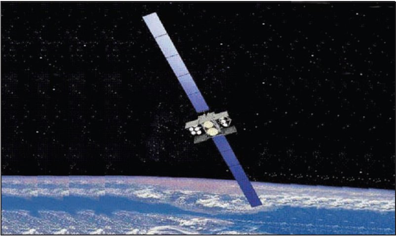
About WGS F7 (USA 263)
WGS F7, also catalogued under the designator USA-263 and carrying the COSPAR identifier 2015-036A, is a United States military communications satellite that forms part of the Wideband Global SATCOM (WGS) constellation. Launched on 23 July 2015, it was the seventh spacecraft to enter orbit under the WGS programme and remains operational today in geostationary orbit. The satellite is managed by the United States Air Force and provides high-capacity communications infrastructure in support of American and allied military operations. With a NORAD catalog number of 40746, it is routinely tracked by ground-based surveillance networks and publicly indexed in space-object databases maintained by U.S. Space Command.
Mission and Purpose
The Wideband Global SATCOM programme was conceived to replace and significantly expand upon the older Defense Satellite Communications System, delivering far greater data throughput to military users across the globe. Where earlier generations of military communications satellites were constrained by narrow bandwidth and limited ground coverage, the WGS architecture was designed to support the full spectrum of modern warfighting communications needs — from high-definition video teleconferencing and intelligence data relay to command-and-control links and tactical battlefield networks.
As the seventh satellite delivered to the constellation, WGS F7 extended both the capacity and the geographic reach of a system that had been steadily built out since the mid-2000s. The WGS family of satellites operates across X-band and Ka-band frequencies, enabling flexible routing of large volumes of data between ground terminals, aircraft, ships, and other military assets. The constellation supports not only U.S. forces but also a number of allied nations that have contributed financially to the programme in exchange for access to its capacity — an arrangement that has made WGS one of the more internationally collaborative elements of American military space infrastructure.
The specific operational role assigned to WGS F7 at its geostationary slot over the Pacific region gives it a coverage footprint that extends across a strategically significant portion of the globe. Its positioning at 135° West longitude places it over the central Pacific Ocean, a region of sustained military and geopolitical interest, connecting assets operating in the Indo-Pacific theatre with command nodes on the continental United States and beyond. While the precise details of its daily operational tasking are not publicly disclosed, its placement within the constellation is consistent with a mission focused on supporting Pacific Command communications requirements.
The satellite was procured by the United States Air Force, which has historically served as the lead service for military space acquisition in the United States. Mission status and operational details are not recorded in the public catalog, which is standard practice for national security space assets of this nature.
Orbit and Tracking
WGS F7 occupies a near-perfect geostationary orbit, as reflected in the tracking data maintained for NORAD catalog object 40746. Its apogee stands at 35,795 kilometres and its perigee at 35,793 kilometres — a difference of only two kilometres, indicating an orbit that is exceptionally circular. This near-zero eccentricity is characteristic of a well-maintained operational geostationary satellite, where onboard propulsion systems perform regular stationkeeping manoeuvres to counteract the perturbing gravitational influences of the Moon, Sun, and Earth's non-uniform gravitational field.
The orbital inclination is recorded at 0.0°, confirming that the satellite's orbital plane is aligned essentially perfectly with Earth's equatorial plane. This is the defining characteristic of a true geostationary orbit: when viewed from a fixed point on Earth's surface, the satellite appears stationary in the sky rather than tracing an arc or figure-eight pattern. An orbital period of 1,436.1 minutes — slightly less than 24 hours — matches the rotational period of Earth to a high degree of precision, which is the fundamental requirement for maintaining a fixed apparent position.
For ground station operators and communications engineers, geostationary positioning offers substantial advantages. A dish antenna pointed at WGS F7 need not track a moving target; once aligned, it can maintain a continuous, uninterrupted link. This makes the geostationary arc particularly well suited to the kind of persistent, high-bandwidth communications relay role that the WGS programme is designed to fulfil. The trade-off — a propagation delay of roughly a quarter of a second each way due to the enormous altitude — is generally acceptable for the data relay and voice communications applications that dominate the WGS mission.
The satellite was launched on 23 July 2015 and, as of the time of writing, remains in orbit with no decay or reentry date recorded. It is classified as a payload object in the space surveillance catalog, distinguishing it from the rocket bodies and debris objects also tracked in the same regime.
Design and Operator
WGS F7 was built for and is operated by the United States Air Force, the branch of the U.S. military that has historically led military space operations and acquisition, a role that has since transitioned in part to the United States Space Force following the latter's establishment in 2019. The satellite was procured as part of the ongoing WGS acquisition effort, which over successive flights delivered progressively refined spacecraft to the constellation.
Manufacturer information for WGS F7 is not publicly recorded in the space surveillance catalog, and no specific mass figure is available in the open-source record. The WGS programme as a whole has involved industrial contractors specialising in large geostationary communications satellites, and the spacecraft family is known publicly to be substantial in size and capability relative to many commercial counterparts — but specific engineering details for this particular spacecraft are not confirmed in verifiable public sources and are therefore not stated here.
The WGS satellites as a class are built around a bus architecture that supports large deployable antenna arrays and a flexible signal-routing payload capable of cross-banding between frequency ranges. This flexibility allows ground operators to dynamically allocate capacity across geographic regions and user communities as demand shifts — a significant operational advantage over earlier, more rigid military satellite designs. The satellites are designed for extended service lives in geostationary orbit, where the remote location and the cost of replacement create strong incentives for maximising operational longevity.
Programme Context and Significance
The Wideband Global SATCOM programme represents one of the most sustained and consequential investments in military communications satellite infrastructure in U.S. history. By the time WGS F7 reached orbit in mid-2015, the constellation had grown from the initial operational capability represented by the first satellites into a mature, multi-spacecraft system spanning multiple geostationary arc positions to provide near-global coverage. The addition of each new satellite in the series incrementally increased total system capacity and provided redundancy against the loss of any single orbital asset.
The strategic rationale for the WGS programme has been consistent across its development: modern military operations are fundamentally dependent on communications bandwidth, and demand for that bandwidth has grown dramatically with the proliferation of unmanned aerial systems, persistent surveillance platforms, and data-intensive command systems. The WGS architecture was designed to scale with that demand in a way that its predecessor systems could not. WGS F7's contribution to that architecture, from its position over the Pacific, supports a region that has grown in strategic prominence throughout the satellite's operational life.
The programme's multinational dimension — with partner nations contributing funds in exchange for capacity access — has also been noteworthy as a model for cooperative satellite communications acquisition. This arrangement allowed the U.S. to partially offset acquisition costs while deepening interoperability with key allies, a formula that has influenced subsequent thinking about allied space cooperation.
Observing WGS F7
WGS F7 sits at an altitude of approximately 35,795 kilometres above the equator, far beyond the range at which most satellites are observed by amateur astronomers. Objects in geostationary orbit do not move against the star field in the way that low-orbit satellites do, which makes casual naked-eye observation effectively impossible. From mid-latitudes in the northern or southern hemisphere, the satellite appears below the horizon or at a low elevation angle, and its extreme distance means it reflects very little sunlight to ground-based observers.
Dedicated observers using telescopes and long-exposure astrophotography can image geostationary satellites as point sources that remain stationary while background stars trail across the frame — the inverse of the trails produced by low-orbit objects. In such images, WGS F7 would appear as a fixed point near the geostationary arc at a right ascension consistent with its 135° West longitude position. Tracking predictions for the satellite are available through the LowEarth platform using the NORAD catalog identifier 40746 and the COSPAR designator 2015-036A, allowing observers and researchers to calculate its current sky position for any given time and location.
Altitude history
Apogee and perigee for WGS F7 (USA 263) across 148 days of archived orbital elements (150 element sets, one per day).
Derived from our own archive of CelesTrak orbital elements, sampled every 3 hours. Short windows show drag and station-keeping; they are not a reentry prediction.
Related satellites
Sources & further reading
Embed this satellite on your site
Free for editorial use. Attribution back to LowEarth is required.
<iframe src="https://lowearth.app/embed/40746" width="640" height="400" frameborder="0" allow="fullscreen"></iframe>