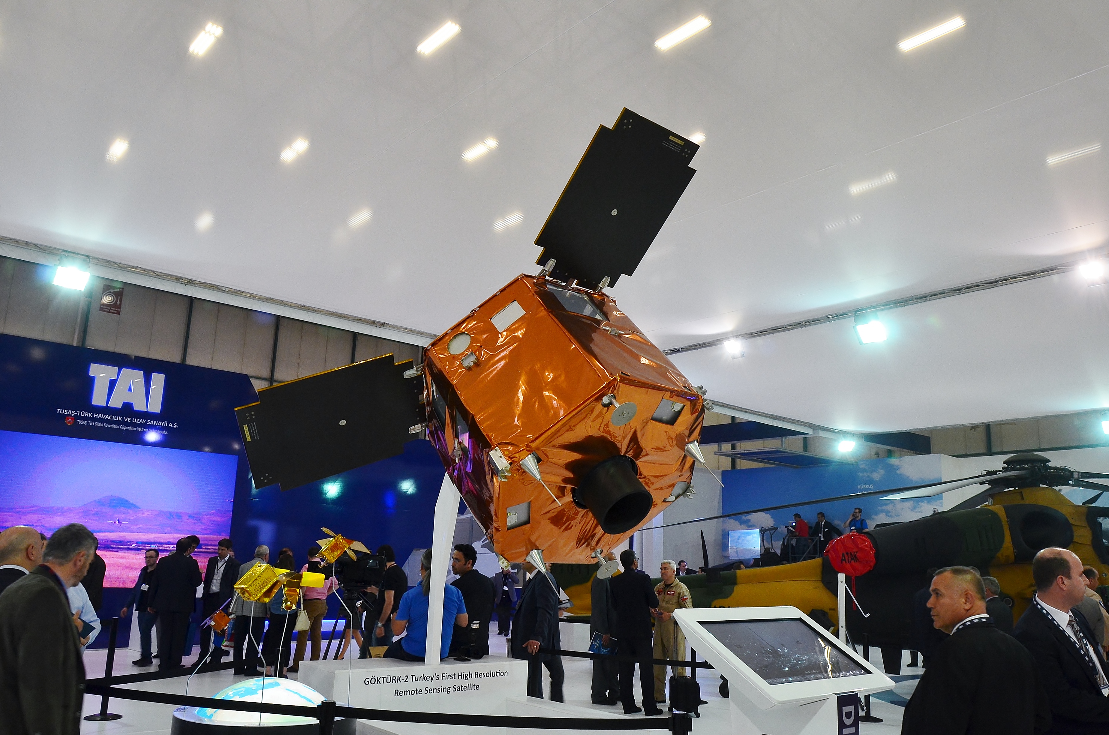
GOKTURK 2
About GOKTURK 2
Göktürk-2 (also written as GOKTURK 2) is a Turkish Earth observation satellite operated by the Ministry of National Defense. Launched on December 17, 2012, it holds NORAD catalog number 39030 and international designator 2012-073A. The satellite marked a significant milestone in Turkey's effort to develop an indigenous space capability, being among the first remote-sensing spacecraft designed and built substantially within the country rather than procured from foreign vendors. As of the time of this writing, it remains in orbit and continues to be tracked.
Mission and Purpose
Göktürk-2 was conceived as part of Turkey's broader strategic ambition to achieve self-sufficiency in satellite-based reconnaissance and surveillance. Operating under the authority of the Turkish Ministry of National Defense, the satellite was intended to provide imagery of the Earth's surface for national security and defense-related applications. Because the mission type and current operational status are not formally recorded in the public satellite catalog, specific details about the imaging instruments it carries and the precise scope of its operational tasking have not been officially confirmed in open sources.
What is clearly established is that the program grew out of an institutional partnership between two major Turkish research and industrial bodies. The Scientific and Technological Research Council of Turkey, known by its Turkish acronym TÜBİTAK, and its subsidiary TÜBİTAK Space Technologies Research Institute led the technical development of the satellite. Turkish Aerospace Industries (TUSAŞ) also contributed to the program, reflecting an effort to pool the country's aerospace engineering expertise into a single national project. This made Göktürk-2 a demonstration not only of operational intent but also of domestic industrial and scientific capability.
The decision to develop a domestically built satellite rather than simply purchasing a foreign system carried political and strategic weight. Satellites used for national security imaging are sensitive assets, and depending entirely on foreign platforms or data-sharing agreements leaves a country subject to the decisions and restrictions of other governments. By designing and assembling Göktürk-2 within Turkey, the Ministry of National Defense and the broader Turkish government sought to reduce that dependency and lay groundwork for future programs.
Orbit and Tracking
Göktürk-2 operates in a sun-synchronous orbit (SSO), a type of nearly polar orbit in which the satellite's orbital plane maintains a consistent angle relative to the Sun throughout the year. This geometry ensures that the satellite passes over any given point on Earth's surface at approximately the same local solar time on each revisit. For Earth observation and reconnaissance missions, this is a highly desirable characteristic because consistent solar illumination makes it easier to compare images taken at different times: shadows fall in similar directions, lighting contrasts remain stable, and ground features are easier to analyze in sequence.
The satellite's current orbital parameters reflect a well-maintained, nearly circular orbit. Its apogee — the farthest point from Earth's surface — stands at approximately 649 kilometers, while its perigee — the closest point — sits at approximately 646 kilometers. The difference between these two values is only about 3 kilometers, making the orbit very nearly circular. This low eccentricity is typical of operational Earth observation satellites, where a stable altitude produces consistent ground resolution pass after pass.
The orbital inclination is 97.7 degrees. An inclination above 90 degrees indicates a retrograde orbit — one in which the satellite travels in the opposite direction to Earth's rotation. Sun-synchronous orbits characteristically require such a slight retrograde tilt to produce the precession needed to keep the orbital plane aligned with the Sun across the changing seasons. At this inclination, the satellite achieves near-global coverage over time, passing over high-latitude regions as well as the equatorial zones.
Each orbit takes approximately 97.5 minutes to complete. At this period, the satellite completes roughly 14 to 15 full orbits in a single day, sweeping different ground tracks on each pass as the Earth rotates beneath it. Over the course of several days, this pattern builds up into coverage of most of the planet's surface, giving operators multiple imaging opportunities over any region of interest.
NORAD catalog number 39030, assigned by the United States Space Surveillance Network, uniquely identifies this object in the global catalog of tracked space objects. The international designator 2012-073A encodes its launch history: the "2012" indicates the year of launch, "073" identifies it as the seventy-third launch of that year, and "A" marks it as the primary payload of that mission. These identifiers are used by tracking systems worldwide to maintain an unambiguous record of the satellite's trajectory.
Design and Operator
The satellite was designed and developed by TÜBİTAK Space Technologies Research Institute, the research arm of TÜBİTAK dedicated to space science and technology. The institute, based in Ankara, has served as the primary technical center for Turkey's ambitions in satellite development and has grown considerably in capability since its founding. The involvement of Turkish Aerospace Industries (TUSAŞ) added industrial manufacturing depth to the project, with that organization contributing to the construction and integration of the spacecraft.
The mass of Göktürk-2 is not recorded in the public satellite catalog, so no figure can be stated here with confidence. What can be noted is that satellites of this orbital class, operating in low Earth orbit at roughly 650 kilometers altitude with defense-oriented Earth observation missions, typically fall within a range of small-to-medium platforms, though the specific design parameters of Göktürk-2 have not been officially disclosed in open sources.
The operator, Turkey's Ministry of National Defense, oversees the satellite as a national security asset. This places Göktürk-2 in the category of government-operated defense satellites, distinct from commercial Earth observation platforms or civilian scientific missions. Operational decisions about tasking, data access, and mission priorities are handled under the authority of the ministry rather than through any civilian or commercial framework.
Significance and Legacy
When Göktürk-2 launched in December 2012, it represented a tangible output of Turkey's long-running effort to build genuine space engineering capability at home. Earlier Turkish satellites had been designed or built with substantial foreign involvement, limiting the degree to which the programs could be considered truly indigenous. The Göktürk-2 program was structured deliberately to maximize domestic participation, treating the satellite itself as an engineering development exercise as much as an operational tool.
The experience gained by engineers and scientists at TÜBİTAK Space Technologies Research Institute during the Göktürk-2 program informed subsequent Turkish space projects. Building a satellite from the ground up — working through the technical challenges of power systems, thermal control, attitude control, communications, and payload integration — produces institutional knowledge that cannot simply be purchased or transferred through licensing agreements. In this respect, Göktürk-2 served a dual function: it delivered an operational defense asset to the Ministry of National Defense while simultaneously educating a generation of Turkish satellite engineers.
The satellite's continued presence in orbit, more than a decade after launch, speaks to the durability of its design. Sun-synchronous orbits at roughly 650 kilometers altitude experience relatively modest atmospheric drag compared to very low Earth orbits, which contributes to longer operational lifetimes. While no official statements about the satellite's current operational condition are available in the public catalog, it has not undergone reentry as of this writing.
Turkey's space sector has expanded considerably since 2012, with the establishment of the Turkish Space Agency and the advancement of more capable successor satellites under the Göktürk program. The earlier work embodied in Göktürk-2 is widely understood to have been a foundation for those subsequent efforts.
How to Spot It
Göktürk-2 orbits at an altitude of approximately 646 to 649 kilometers in a sun-synchronous, near-polar orbit, which means it passes over most latitudes on a regular basis — including the majority of populated areas in Europe, Asia, the Middle East, and beyond. With an orbital period of 97.5 minutes, it completes numerous passes each day, and from any given location on the ground it will appear overhead multiple times per week.
Whether it is visible to the naked eye on any particular pass depends on the geometry of sunlight. Like all unlit satellites, Göktürk-2 is only observable when it is in sunlight while the observer on the ground is in darkness — typically in the hours just after sunset or just before sunrise. During these windows, the satellite may be seen as a steadily moving point of light crossing the sky over the course of a few minutes. It will not flash or blink the way aircraft do, and it will not show the colored navigation lights characteristic of aircraft. The brightness of its appearance will vary depending on its attitude and the angle of solar reflection.
Precise predictions for upcoming passes over any specific location can be generated using the tracking tools available on this site, based on the current two-line element set associated with catalog number 39030.
Related satellites
Sources & further reading
Embed this satellite on your site
Free for editorial use. Attribution back to LowEarth is required.
<iframe src="https://lowearth.app/embed/39030" width="640" height="400" frameborder="0" allow="fullscreen"></iframe>